This 18-month process will be the first time Knox County has created an integrated land use and transportation plan, and it has the potential to be transformative.
It is crucial that this plan be built on the values, needs, and aspirations of people throughout the county, and be supported by good data. There will be multiple opportunities for community input and feedback throughout the process.
What
Why
Who's Involved
Timeline
FAQ
What is a Comprehensive Land Use and Transportation Plan?
A Comprehensive Plan is a long-term guide that expresses the values, aspirations, needs, and unique conditions of a community. The Comprehensive Land Use and Transportation Plan will establish an integrated vision for growth and infrastructure investment and address many related topics that impact the county’s quality of life today and in the future. The plan is a tool to prepare for change and acts as both a business plan and guidebook for decision-makers.
Why does Knox County need this plan?
In general, planning is good stewardship. Knox County has long been a place that attracts new residents, invests in jobs, and has a strong sense of community pride. It is also a place that continues to rapidly change, on track for another record-breaking year for building permits. This plan will be the first to integrate land use and community design with transportation and other topics. It will guide decisions about where and how growth occurs and where investments in infrastructure and services are made throughout the county.
Who's Involved
Consultants
Process leadership, expertise
Kimley-Horn and Planning NEXT will facilitate the process and share experience from other successful communities. Cannon & Cannon, Ninigret Partners, and Urban 3 will provide technical and subject matter expertise.
Staff
Coordination
Staff from Knox County and Knoxville-Knox County Planning will support and help coordinate the work of all other groups and provide local knowledge and expertise.
Advisory Committee
Process, substance, and community outreach
A diverse group of community members that will provide guidance on the process and substance of the plan and will serve as community advocates.
Kim Bumpas, Visit Knoxville
Claudia Caballero, Centro Hispano
Scott Davis, Eagle Bend Development & Construction
Carol Evans, Legacy Parks
Kevin Murphy, Knox County Planning Advocates
Duane Grieve, East Tennessee Community Design Center
Maribel Koella, Urban Land Institute of Knoxville
Phyllis Nichols, Knoxville Area Urban League
Mitchel Olszewski, AARP
Hancen Sale, Knoxville Area Association of Realtors
Josh Sanderson, Smithbilt Homes
Zoe Scott, Bike Walk Knoxville
Russ Watkins, Partners Development
James Artman
Peter Curtis
Crystal Fields
Gayla Guignard
Jennifer Kerr
Cassie Kiestler
Benjamin King
Cormac Mohan
Carol Montgomery
Wolf Naegeli
Richard Aaron Price
Jennifer Sepaniak
Nathan Sivley
Christopher Wade
Technical Committee
Local subject matter experts and advisors
A group of community members with specific technical knowledge that will provide direction at major milestones in the process.
Knox County Schools
Knox County Health Department
Knox County Parks and Recreation
Knox County Soil Conservation District
Knox County Sherriff's Office
Knox County Community Action Committee
East Tennessee Human Resource Agency
Tennessee Department of Transportation
Knoxville Area Transit
City of Knoxville Economic and Community Development
City of Knoxville Engineering
City of Knoxville Parks and Recreation
Knoxville Chamber
Town of Farragut
Town of Farragut Community Development
Subcommittees
Topical direction
Two subcommittees, focused on schools and utilities, and composed of members of the Advisory Committee and technical committee, will provide input and direction related to those topics.
Knoxville Utilities Board
Hallsdale-Powell Utility District
First Utility District of Knox County
West Knox Utility District
Knox Chapman Utility District
Northeast Knox Utility District
Lenoir City Utility Board
Luttrell-Blaine-Corryton Utility
Tennessee Valley Authority
School Subcommittee Representatives
Knox County Schools
Stakeholders
Targeted input
Additional topical focus groups will be convened to inform specific aspects of the plan. These groups include business leaders, neighborhood associations, real estate professionals and developers, education professionals, students, and others.
Public
Input and feedback
Community participation is vital to the plan’s success. Three rounds of input opportunities and online tools will offer a variety of different ways for the community to give input throughout the process.
Elected Officials
Monitor and adopt
County Commission will monitor the process through input and periodic briefings with the expectation to formally adopt the final plan. The Commission will have a central role in implementation through regulatory updates or funding allocations.
Project Timeline
This is a significant undertaking that will last approximately 18 months. It is expected to be complete near the end of 2023. There will be multiple opportunities for community input beginning in early 2022. The timeline is subject to change throughout the life of the project.
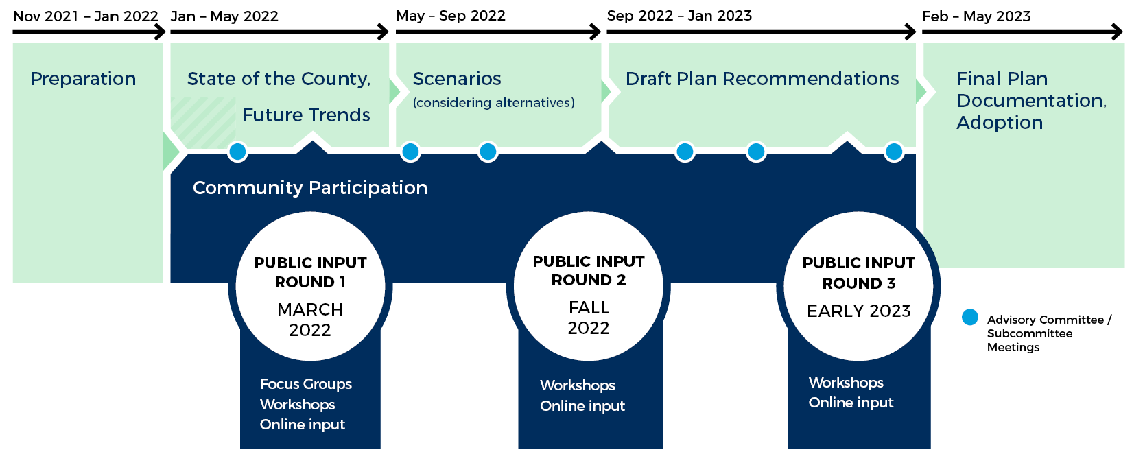
- November
- 11/1Project preparation begins
- December
- 12/1Countywide tour - Consultants and staff
- January
- 1/1State of the County and Future Trends - Work begins
- February
- 2/1Advisory Committee
- 2/1Technical Committee
- March
- 3/1Public Input - Round 1
- April
- 4/1Advisory Committee
- 4/1Technical Committee
- May
- 5/1Scenario Planning - Work begins
- July
- 7/1Advisory Committee
- 7/1Technical Committee
- October
- 10/1Public Input - Round 2
- December
- 12/1Advisory Committee
- 12/1Technical Committee
- February
- 2/1Draft Plan recommendations
- March
- 3/1Public Input - Round 3
- 3/1Advisory Committee
- 3/1Technical Committee
- April
- 4/1Final Plan documentation
- November
- 11/1Plan adoption process
- June
- UDO Technical Committee Meetings
- September
- UDO Public Open House Events
- UDO Drafting Begins
- May
- UDO Technical Committee Meetings
- UDO Public Open House Events
- July
- UDO Adoption Process Begins
2021
2022
2023
2025
2026
Want to know more about the process?
When will the plan be completed?
Plan adoption is expected to take place in early 2024. A project timeline will be maintained to keep track of major milestones in the process.
How can the public get involved in this project?
There will be three rounds of community engagement throughout the process. The website will share information on upcoming public meetings, surveys, and other ways to get involved, and individuals can sign up to receive email updates.
Are the City of Knoxville and Town of Farragut included in the plan?
Both jurisdictions will participate as key stakeholders and are invested in the outcome. However, the plan will apply only to the unincorporated parts of Knox County. The County planning effort will focus on coordination among the three jurisdictions and may propose planning solutions to the City of Knoxville and Town of Farragut as appropriate.
How does it relate to other plans used by Knoxville-Knox County Planning?
This plan will establish policies, principles, and concepts that guide future development and preservation. It will inform land use maps, zoning, and other smaller area plans and studies. It will also update the boundaries in the Growth Policy Map that determine planned growth and rural areas, though approval and adoption of this map requires a separate process.
What is the process for the plan to be adopted?
Advance Knox began at the end of 2021 and is expected to take approximately 18 months. To be adopted, the final plan will first be heard by the Knoxville-Knox County Planning Commission. It will then go to Knox County Commission and requires two readings.
Will the Growth Policy Plan and the Comprehensive Land Use and Transportation Plan be adopted simutaneously?
The original process established the Growth Plan boundaries prior to the Comprehensive Plan (or General Plan in 2003), but the two plans were updated together this time. The Growth Plan boundaries and place types found in the Future Land Use Map are closely related and inform one another, and because of this, the project team intends to move them through their respective legislative processes at the same time. The amended Growth Policy Plan and map will be considered by the Coordinating Committee and then must be approved by Knox County Commission, Knoxville City Council, and Farragut Board of Mayor and Aldermen. The Comprehensive Land Use and Transportation Plan will first be considered by the Knoxville-Knox County Planning Commission and then by Knox County Commission.
Will Sector Plans continue to be updated after the Comprehensive Plan is adopted?
At the time of adoption, the Knox County Comprehensive Land Use and Transportation Plan will replace sector plans within unincorporated Knox County. The county recognizes the important research, community context, and public input that informed those plans, which is why both the sector plans and the sector plan map were used to draft the proposed Comprehensive Plan and Future Land Use Map. Adopted small area studies and corridor studies were also consulted during the development of the Comprehensive Plan but will remain as stand alone studies.
Moving forward, Knox County's sector plans will not be updated. However, the Comprehensive Plan will be updated on a five-year cycle, referred to on page 69 of the draft Plan, and the county intends to work on small area plans and corridor studies as future needs arise. Additionally, Panorama is a tool created by Planning staff to stay up-to-date on data related to the people and places of Knox County, serving the same role as the background reports in sector plans. The data used within this tool is updated frequently and allows users to stay informed of trends and conditions throughout the county. Panorama is set up to continue to monitor sectors or other smaller geographic areas.
What were the criteria and procedure for designating place types and their boundaries?
Extensive place type definitions are available in Supplement B of Appendix B of the Comprehensive Plan. Once defined, those place types were assigned to polygons within each scenario consistent with the concept maps that were presented to the public during the "Choices" round of outreach.
What will happen during the time between when the Comprehensive Plan is approved and the point when the Unified Development Ordinance takes effect? Will Current Zoning Categories be determined to fit within each place type for the time being?
Knox County is working towards creating a Unified Development Ordinance, which would include an update to the zoning code. That process is anticipated to begin in 2024, so there will be a transition period. Guidance for how the proposed place types could be implemented by the existing zoning code is provided on page 469 of the draft Comprehensive Plan Appendices.
Does the proposed Growth Policy Plan amendment state that Specific growth areas Would ONLY Allow zones that are consistent with the place type indicated in the Future Land Use Map?
Any land use that is allowed within the zoning code could be permitted, but rezonings would be required to be consistent with the Future Land Use Map and Comprehensive Plan.
What are the reasons for proposing expansion of growth areas in specific areas? Is sewer availability a factor?
As seen on page two of the Amendment of the Growth Policy Plan, "Knox County embarked on a two-year process to create an integrated land use and transportation plan for the unincorporated county in 2021. The resulting future land use plan and the designation of rural and planned growth areas included in this growth plan was formed through careful consideration of citizens, community groups and businesspeople. It was based on existing conditions and infrastructure, trends in land use, population and the natural environment; and input by the citizens and detailed testimony by a wide variety of governmental service providers, including city and county departments, utility districts, emergency services and the school board." Sewer capacity and accessibility was a consideration in the scenario planning process and confirmed with utility providers through the Utility Subcommittee.
What projections, determinations, and reports required by TCA 6-58-106 were produced, and where can they be viewed by the public?
The Draft Comprehensive Land Use and Transportation Plan includes a series of appendices that provide detail on the data analysis conducted as part of the plan development.
Is there an updated land capability analysis for the Growth Policy Plan?
During this process, a land use model was created to develop and evaluate alternative scenarios. The model has several components, including the evaluation of land use capacity, which incorporates the "carrying capacity" of land. It also includes a suitability analysis that determines how attractive land is for development. These items can be found in Appendix B of the Comprehensive Plan.